Storm Attributes show information about the severity of storms. This information is recorded by NEXRAD sites wherever there is heavy precipitation. Storm attributes include the direction and speed of the storm over time, as well as the elevation of the top of the storm. Measured in 100s of feet, this value indicates the height of rain within the storm.
The higher the values, the more intense a thunderstorm is likely to be. Additional information can be displayed: mesocyclonic activity (MESO) – a strong wind vortex, tornado activity (TVS), and the presence or possibility of hail. This feature is available over the Continental United States. Updated every 5 minutes.
This colour-coded image shows a complete view of any precipitation across North America, including the type and severity. Rain is shown as light green, dark green, yellow, orange and red as intensity increases. Hail, freezing rain and snow are represented with colours from bright pink to blue. The images are displayed as pixels on screen and the resolution of this feature is 2 km per pixel. Coverage includes the Continental US, Canada, and portions of Mexico. Updated every 5 minutes.
The Lightning feature contains the latitude and longitude of each cloud-to-ground and cloud-to-cloud lightning strike detected in the five minutes prior to the time stamp displayed on the screen. It uses the National Lightning Detection Network (NLDN), the official lightning detection for the U.S. National Weather Service – the most accurate and reliable large-scale lightning detection network in the world. Updated every 2.5 minutes.
Tropical Storm tracks and displays the past and forecast position of a tropical system as well as its wind fields. This feature is available over the Atlantic and Eastern Pacific and updated when the National Hurricane Center has identified and is tracking a tropical storm or hurricane. Updated as issued.
Alerts can be set to appear and display warnings for weather changes in a selected area helping to provide advance warnings of changing weather conditions.
Weather watch boxes can be set to appear when weather in a selected area is changing. Updated every hour.
This is a 5-day overview of the weather based on the closest major metropolitan area to the selected location. Updated every 6 hours.
Offshore surface Winds provides a graphical model of surface wind conditions 24NM from shore and beyond. The display is either an arrow showing the wind’s direction, or a ‘wind barb’ to reflect direction and speed. The display can be set to show the current/most recent conditions, or to show the forecast up to 48 hours ahead. Updated every 3 hours.
This High-Res wind feature displays surface wind conditions inland and up to 24NM from shore. The display is either an arrow showing the wind’s direction, or a ‘wind barb’ to reflect direction and speed. The display can be set to show the current/most recent conditions, or to show the forecast up to 24 hours ahead. Updated every hour for 0 hour forecast wind and every 3 hours, for 3, 6, 9, 12, 18 and 24 hour forecast winds.
The Weather Map displays high (‘H’) and low (‘L’) pressure systems. Pressure is measured at the center of the system in millibars. The map also indicates cold and warm fronts, the front’s direction of movement, Pressure Centers (High and Low Pressure), and Isobars (lines of equal pressure). It can be set to show the current conditions, or to show the forecast up to 48 hours ahead. Updated every 3 hours for 0 hour surface features, every 6 hours for 12-24 hour surface features, and every 12 hours for 36-48 hour surface features.
The Wave feature provides a colour-coded display forecasting the height, period (time between swells) and direction of ocean waves in 0, 3, 6, 9, 12, 18, 24, 36 and 48 hour forecast – 24NM offshore and beyond. Colors range from blue to green to yellow to red depending on the wave’s height. Dark blue denotes waves 1 ft. or less. Red indicates waves 20 ft. or higher. The Wave Period is provided numerically in seconds. An arrow shows the direction the swells are moving. This forecast is available for the Atlantic and Pacific oceans. Updated every 6 hours.
High-Res Wave information displays forecasts of the height in 0, 6, 12, 18, and 24-hour increments – up to 24NM from shore. Colors range from blue to green to yellow to red depending on the wave’s height. Dark blue denotes waves 1 ft. or less. Red indicates waves 20 ft. or higher. This forecast is available for the Atlantic and Pacific oceans. Updated every 6 hours.
Great Lakes Waves displays forecasts of the height, period (time between swells), and direction of waves in the Great Lakes in 0, 6, 12, 18, and 24-hour increments. Colors range from blue to green to yellow to red depending on the wave’s height. Dark blue denotes waves 1 ft. or less. Red indicates waves 20 ft. or taller. The Wave Period is provided numerically in seconds. An arrow shows the direction the swells are moving. Updated every 6 hours.
Marine warnings are displayed for designated marine zones. Select a particular zone to receive hazardous weather warnings for that region. Updated every hour.
NOAA has divided all coastal offshore waters into Marine Zones – then they provide localized weather information for each zone. Select a marine zone to view the written forecast for that region. Updated every 30 minutes.
Tropical Weather Statements provide reports and forecasts related to tropical weather conditions. Updated every hour.
The METAR feature summarizes the most recent weather conditions observed for that location. Coverage extends in North America beyond the continental US. See our service Coverage Map. Updated every 15 minutes.
NOAA maintains weather stations on buoys with sensors on board to record weather conditions. This data can be displayed by selecting a sensor at a specific buoy on the map. Data available may vary but includes time the conditions were recorded, buoy location, water temp, air temp, humidity, wind speed and direction, wave height, wave period (time between swells), wave direction and barometric pressure. Updated every 10 minutes.
Cloud Top images provide satellite data of clouds, based on temperature – colder cloud tops are typically found at higher altitudes. Using a model, temperatures are transformed into cloud top height and contours. The height of the cloud top is displayed in increments of 5,000 ft. This feature covers the Continental United States. Updated every hour.
High-Res Coastal Sea Surface Temp provides a graphical representation of the water’s surface temperature measured in 1 degree Fahrenheit increments out to 24NM from the shoreline. This is presented on the map either as a colour contour or written text. Sea surface temperatures are used by anglers to determine favourable location for specific types of fish. They are also used to predict potential development of tropical systems, formation of sea breezes and fog. Temperature data utilizes satellite observations and modeling for forecasts and includes Great Lakes coverage. Resolution for coastal SST is 1km. Updated every 3 hours.
Offshore Sea Surface Temp provides a graphical representation of the water surface temperature measured in 1 degree Fahrenheit increments 24NM from the shoreline and beyond. This is presented on the map either as a color contour or written text. Sea surface temperatures are used by anglers to determine favourable location for specific types of fish. They are also used to predict potential development of tropical systems, formation of sea breezes and fog. Temperature data utilizes satellite observations and modeling for forecasts. Resolution for Offshore SST is 4km. Updated every 3 hours.
SiriusXM satellite radio service provides access to over 300 channels including commercial-free music with exclusive performances and artist dedicated channels; coverage of every major sport and dedicated talk channels for all major professional sports, college sports and fantasy; the biggest names in entertainment and talk cover everything from comedy to politics and religion; breaking news from the most trusted sources. SiriusXM Radio is an optional service, with a discount applied automatically when it is added to a Marine service subscription plan.
Get a $100 rebate
With the purchase and subscription activation of an eligible marine weather receiver.
Help and support

Send a refresh signal
Haven’t taken the boat out in a while? We can send a “wake up” signal to your hardware.

Service coverage area
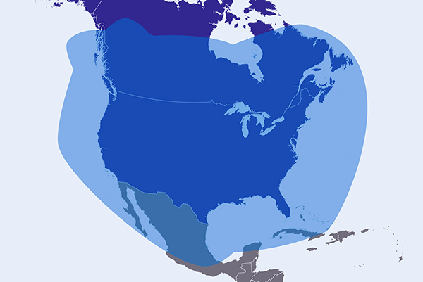
SiriusXM Marine service is available in the continental United States, southern Canada and coastal regions, up to 150 nautical miles offshore.
Need some extra assistance?
Call 1-844-823-0843 or email marine@siriusxm.ca for personalized help with SiriusXM Marine. You can also log in to your account if you have account specific issues.
Frequently Asked Questions
What hardware do I need to access SiriusXM Marine Weather?
You will need a chartplotter/MFD and a compatible receiver from one of the leading marine electronics brands. Our marine service is available on B & G, Furuno, Garmin, Lowrance, Raymarine and Simrad products using compatible marine receivers.
Can I suspend my service when my boat is out of the water or not in use for a period of time?
We allow customers to “Seasonally Suspend” service at no charge for up to 6 months when their boat is not in use.
How can I get SiriusXM Satellite Radio (audio service) on my boat?
You can add SiriusXM Satellite Radio to your SiriusXM Marine Service. If your hardware is compatible, you can access and control satellite radio through the same equipment that you access our weather service. You can also purchase a separate SiriusXM Satellite Radio or tuner and an audio subscription and connect it to the stereo head unit audio system on your boat.
If it has been more than a month since I last used my SiriusXM Marine receiver, what should I do to ensure that it works when I need it?
You can send a refresh signal to your receiver at siriusxm.ca/refresh on your smartphone or computer or call 1-844-823-0843. You will need your Radio ID/ESN.

